Tom's Neck 3
In Tom's Neck 1 and Tom's Neck 2 we looked at a new set of pictures I made a few weeks ago on the island of Chappaquidick, off of Martha's Vineyard, MA.
In this post, we'll finish the Tom's Neck series.
But before we conclude, I also worked to extend from some of the "facade" ideas, to lend to the depth of the project but also to allow some actual depth (foreground to background) into the pictures as well.

I did that by beaching the boat, getting out and photographing conventionally, both with the moderate wide angle lens I'd already been using, but with a longer lens as well.


I was seeking to convey a greater immersion into the landscape, as opposed to sitting outside of it and photographing like an observer.
I also used files shot aerially that gave a broader perspective on the area from a different angle:


When photographing aerially it becomes hugely important to "get it all". This simply means to circle areas that are crucial, to photograph them with front light and back light too, as reshoots are almost always not possible.
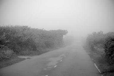
As I headed farther down the inlet that is Tom's Neck in the kayak I was confronted with a choice. I could go down to the very end where there is a sandy beach and a point:
 or contain the series within the framework I'd already established. I chose the latter.
I know, if you've followed along and are invested you may be saying, "Neal, you idiot! What were you thinking?"and I will have to live with that. My reasoning was that the series was beginning to head off into something different and would therefore dilute the impact and cohesion of the other pictures. I was already doing quite a bit in a group of pictures: telling a story, representing a finite area with pictures taken weeks apart, from the air and from a boat. Let me show you what I did conclude with. After making several more like this:

and

I paddled across the inlet to get more distance from the Neck than before:

and

Then, for the last picture, paddled back across the inlet to turn the boat around 180 degrees on what I'd been photographing, putting Tom's Neck at my back, and made this picture:

For the first time we are seeing what else was out there. This isn't that unusual a thing for me to do at the end of a highly sequenced series, where I tell a story or take us on a journey. It is also structurally similar to the first in that it is three horizontal bands.
For the sake of the blog I can show you what all this is:

(Thanks to Google Maps)
The red X marks about where I made the last picture from. You can also clearly see where I had worked for all of these pictures, from the Dike Bridge at the bottom of the map all the way up to Tom's Neck Point.
The last photograph is the image that intends to lead the way out, or to another place or perhaps another series over the horizon, yet to come. What's on the other side of that spit of sand, beyond those bushes?
So that is the new series of pictures I made above and in the water of Tom's Neck on Chappaquidick Island.
I hope you like them. It is not hard to let me know what you think: Neal's Email
BTW: I leave for Paris in a couple of days. When I get there I will drive down to northern Italy to stay with friends, then drive back for Paris Photo the middle of the month. I plan on posting while away. Hope you can come along for the ride. Will I photograph? Is the sky blue?
Thanks for reading.
Related series
Spring & Fall, MV
These are pictures made of Martha's Vineyard Island in Massachusetts in May, 2103.
They combine aerial photographs of the island with those made on the ground of the same area and also pair color with black and white images in the same series.
I have written about the new series while in process on my blog: New Way and New Way 2.
And an explanation of the final series and why I chose the title is here : Spring & Fall
The 22 prints are 18 x 12 inches on 22 x 17 inch archival inkjet paper.
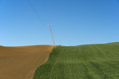
Wheat 2014 Function
Artist Statement: Wheat
Neal Rantoul
I first started photographing in the Palouse area of southeastern Washington in the mid 90’s and have been back most years since. It is my longest running project.
The work has evolved over the years, going from first black and white to color, from large format to digital, and from being based on the ground to including pictures made from the air. I have also photographed the area through the seasons.
In earlier writing about the project I referenced some of the great contemporary landscape photographers such as Robert Adams and Joe Deal, who was a good friend, and also cited Eugene Atget for the single mindedness of his intent. As a career artist I work in many different genres but this is the one that is perhaps the core vehicle of expression for my landscape work. While it has been challenging to find new approaches to this most wonderful of places, it also has been a privilege. Looking back at so much work now, I see more subtle changes from the earlier days to the present for I believe some of the basic principles in working there still apply: it is a landscape almost without scale due to few trees and little to reference size, the pictures can convey the movement of the wheat in the breeze at the same time as show the stillness and static nature of the topography, allowing photographs that convey sharpness and blur due to movement in the same image simultaneously and finally, in the more recent work since about 2000, colors, on their own, but also in relationship to each other.
I am very excited by the newest aerial work from the summer of 2014, as it represents a shift in intention with an evolved sense of the fields' function and their form where the work is perhaps its most abstract. Some of this work references the place by including a barn, a farm machine or trees, while some does not. Hence: Function and Form, the title for the new work. Function and Form constitutes a subset, which is, I hope, a powerful one, of the overall work made over the two-week shoot.
Neal Rantoul
July 2014
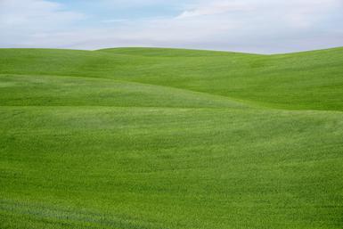
Wheat 2014 Form
Artist Statement: Wheat
Neal Rantoul
I first started photographing in the Palouse area of southeastern Washington in the mid 90’s and have been back most years since. It is my longest running project.
The work has evolved over the years, going from first black and white to color, from large format to digital, and from being based on the ground to including pictures made from the air. I have also photographed the area through the seasons.
In earlier writing about the project I referenced some of the great contemporary landscape photographers such as Robert Adams and Joe Deal, who was a good friend, and also cited Eugene Atget for the single mindedness of his intent. As a career artist I work in many different genres but this is the one that is perhaps the core vehicle of expression for my landscape work. While it has been challenging to find new approaches to this most wonderful of places, it also has been a privilege. Looking back at so much work now, I see more subtle changes from the earlier days to the present for I believe some of the basic principles in working there still apply: it is a landscape almost without scale due to few trees and little to reference size, the pictures can convey the movement of the wheat in the breeze at the same time as show the stillness and static nature of the topography, allowing photographs that convey sharpness and blur due to movement in the same image simultaneously and finally, in the more recent work since about 2000, colors, on their own, but also in relationship to each other.
I am very excited by the newest work from the summer of 2014, as it represents a shift in intention with an evolved sense of the fields' function and their form where the work is perhaps its most abstract. Some of this work references the place by including a barn, a farm machine or trees, while some does not. Hence: Function and Form, the title for the new work. Function and Form constitutes a subset, which is, I hope, a powerful one, of the overall work made over the two-week shoot.
Neal Rantoul
July 2014